Thank you for supporting this site ❤️
Make a donation
Make a donation
Gear up for your next adventure:
As an Amazon Associate, this site earns from qualifying purchases at no extra cost to you.
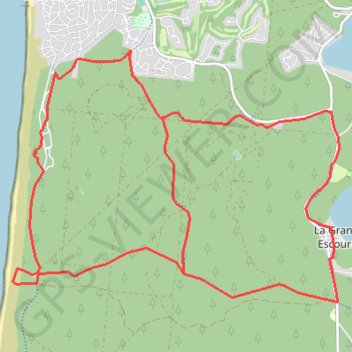
Boucle du Lion
- Distance: 20.8 Km
- Elevation gain: 106 m
- Maximum elevation: 26 m
- Elevation loss: 102 m
- Minimum elevation: 7 m
Interactive trail map
Thank you for supporting this site ❤️
Make a donation
Make a donation
Gear up for your next adventure:
As an Amazon Associate, this site earns from qualifying purchases at no extra cost to you.
Trail profile
- Distance: 20.8 Km
- Elevation gain: 106 m
- Maximum elevation: 26 m
- Elevation loss: 102 m
- Minimum elevation: 7 m
Thank you for supporting this site ❤️
Make a donation
Make a donation
Gear up for your next adventure:
As an Amazon Associate, this site earns from qualifying purchases at no extra cost to you.
About this trail
Name: Boucle du Lion trail, distance, elevation, map, profile, GPS track
Coordinates: 44.95932 -1.20568 44.99400 -1.14246
Thank you for supporting this site ❤️
Make a donation
Make a donation
Gear up for your next adventure:
As an Amazon Associate, this site earns from qualifying purchases at no extra cost to you.
Other hiking, mountain biking, running and outdoor activity trails
Click on a trail to view its statistics, map and profile.
Chemin de Saint-Jacques-de-Compostelle
Switzerland > Geneva > Geneva
Distance: 1,117.8 Km • Elevation gain: 25,262 m • Maximum elevation: 1,430 m