Peekaboo Loop from Bryce Point
Interactive trail map
Trail profile
- Distance: 8.4 Km
- Elevation gain: 515 m
- Maximum elevation: 2,535 m
- Elevation loss: 515 m
- Minimum elevation: 2,270 m
About this trail
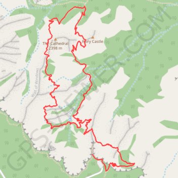
Name: Peekaboo Loop from Bryce Point trail, distance, elevation, map, profile, GPS track
Start: Rim Trail, Garfield County, Utah, United States (37.60483 -112.15750)
End: Rim Trail, Garfield County, Utah, United States (37.60483 -112.15750)
Coordinates: 37.60336 -112.16285 37.61761 -112.15287
Other hiking, mountain biking, running and outdoor activity trails
Click on a trail to view its statistics, map and profile.
Figure-8 Combination Loop (Bryce Canyon)
United States > Utah > Garfield County
From Sunset Point, the route first follows the rim toward Sunrise Point, opening broad views over the Bryce Amphitheater before dropping into Queen’s Garden, where pale orange hoodoos, sculpted walls, and fir-dotted slopes gradually surround the trail. The descent leads from the overlook atmosphere of the…
Distance: 10.3 Km • Elevation gain: 500 m • Maximum elevation: 2,431 m
Peekaboo Loop Trail in Bryce Canyon National Park
United States > Utah > Garfield County
The Peekaboo Loop Trail in Bryce Canyon National Park offers hikers an immersive journey through a landscape adorned with towering red and orange hoodoos. As you navigate the trail, you'll encounter notable formations such as the Wall of Windows, the Cathedral, Hindu Temples, Fairy Castle and Peek-a-Boo Arch…
Distance: 8.1 Km • Elevation gain: 483 m • Maximum elevation: 2,536 m
Navajo Loop Trail and Peekaboo Loop Trail in Bryce Canyon National Park
United States > Utah > Garfield County
The combined Navajo Loop and Peekaboo Loop trails in Bryce Canyon National Park offer hikers an immersive journey through the park's iconic red rock formations. The Navajo Loop takes hikers through narrow passages between towering hoodoos, with stunning views of the park's signature rock formations such as the…
Distance: 8.6 Km • Elevation gain: 478 m • Maximum elevation: 2,441 m
Bryce Canyon National Park Peek-a-Boo Loop
United States > Utah > Garfield County
BCNP
Distance: 25.6 Km • Elevation gain: 835 m • Maximum elevation: 2,539 m