Thank you for supporting this site ❤️
Make a donation
Make a donation
Gear up for your next adventure:
As an Amazon Associate, this site earns from qualifying purchases at no extra cost to you.
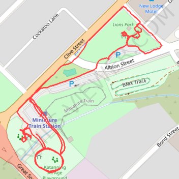
Park footpaths, Katanning All Ages Park, Western Australia
- Distance: 2.0 Km
- Elevation gain: 5 m
- Maximum elevation: 310 m
- Elevation loss: 5 m
- Minimum elevation: 305 m
- Moving time: 26 m 24 s
- Moving speed: 4.6 Km/h
- Maximum speed: 6.5 Km/h
- Total time: 26 m 24 s
- Global speed: 4.6 Km/h
Interactive trail map
Thank you for supporting this site ❤️
Make a donation
Make a donation
Gear up for your next adventure:
As an Amazon Associate, this site earns from qualifying purchases at no extra cost to you.
Trail profile
- Distance: 2.0 Km
- Elevation gain: 5 m
- Maximum elevation: 310 m
- Elevation loss: 5 m
- Minimum elevation: 305 m
- Moving time: 26 m 24 s
- Moving speed: 4.6 Km/h
- Maximum speed: 6.5 Km/h
- Total time: 26 m 24 s
- Global speed: 4.6 Km/h
Thank you for supporting this site ❤️
Make a donation
Make a donation
Gear up for your next adventure:
As an Amazon Associate, this site earns from qualifying purchases at no extra cost to you.
About this trail
Name: Park footpaths, Katanning All Ages Park, Western Australia trail, distance, elevation, map, profile, GPS track
Coordinates: -33.69746 117.54822 -33.69423 117.55160
Thank you for supporting this site ❤️
Make a donation
Make a donation
Gear up for your next adventure:
As an Amazon Associate, this site earns from qualifying purchases at no extra cost to you.