Thank you for supporting this site ❤️
Make a donation
Make a donation
Gear up for your next adventure:
As an Amazon Associate, this site earns from qualifying purchases at no extra cost to you.
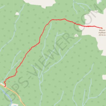
Mount Haffner
Kootenay National Park. #Hiking #Snowshoeing #Kootenay
- Distance: 9.3 Km
- Elevation gain: 1,117 m
- Maximum elevation: 2,528 m
- Elevation loss: 1,117 m
- Minimum elevation: 1,411 m
Interactive trail map
Thank you for supporting this site ❤️
Make a donation
Make a donation
Gear up for your next adventure:
As an Amazon Associate, this site earns from qualifying purchases at no extra cost to you.
Trail profile
- Distance: 9.3 Km
- Elevation gain: 1,117 m
- Maximum elevation: 2,528 m
- Elevation loss: 1,117 m
- Minimum elevation: 1,411 m
Thank you for supporting this site ❤️
Make a donation
Make a donation
Gear up for your next adventure:
As an Amazon Associate, this site earns from qualifying purchases at no extra cost to you.
About this trail
Name: Mount Haffner trail, distance, elevation, map, profile, GPS track
Coordinates: 51.13169 -116.12898 51.15014 -116.08653
Topography: Area G (Forster Creek/Mount Assiniboine) topographic map, elevation, terrain
Thank you for supporting this site ❤️
Make a donation
Make a donation
Gear up for your next adventure:
As an Amazon Associate, this site earns from qualifying purchases at no extra cost to you.