Make a donation
Gear up for your next adventure:
As an Amazon Associate, this site earns from qualifying purchases at no extra cost to you.
The Butchart Gardens Loop
Interactive trail map
Make a donation
Gear up for your next adventure:
As an Amazon Associate, this site earns from qualifying purchases at no extra cost to you.
Trail profile
- Distance: 1.6 Km
- Elevation gain: 35 m
- Maximum elevation: 35 m
- Elevation loss: 35 m
- Minimum elevation: 15 m
Make a donation
Gear up for your next adventure:
As an Amazon Associate, this site earns from qualifying purchases at no extra cost to you.
About this trail
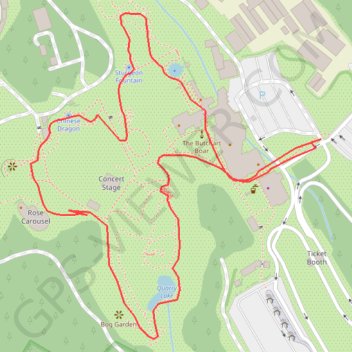
Name: The Butchart Gardens Loop trail, distance, elevation, map, profile, GPS track
Coordinates: 48.56287 -123.47100 48.56647 -123.46615
Topography: Capital Regional District topographic map, elevation, terrain
Make a donation
Gear up for your next adventure:
As an Amazon Associate, this site earns from qualifying purchases at no extra cost to you.
Other hiking, mountain biking, running and outdoor activity trails
Click on a trail to view its statistics, map and profile.
BBF loop to the Skydeck in Nanaimo
Canada > British Columbia > Cowichan Valley Regional District > Area A (Mill Bay / Malahat) > Mill Bay
BBF loop to the Skydeck
Distance: 323.5 Km • Elevation gain: 6,222 m • Maximum elevation: 706 m