Thank you for supporting this site ❤️
Make a donation
Make a donation
Gear up for your next adventure:
As an Amazon Associate, this site earns from qualifying purchases at no extra cost to you.
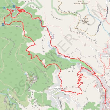
Valle delle Ferriere
- Distance: 9.8 Km
- Elevation gain: 735 m
- Maximum elevation: 482 m
- Elevation loss: 760 m
- Minimum elevation: 23 m
Interactive trail map
Thank you for supporting this site ❤️
Make a donation
Make a donation
Gear up for your next adventure:
As an Amazon Associate, this site earns from qualifying purchases at no extra cost to you.
Trail profile
- Distance: 9.8 Km
- Elevation gain: 735 m
- Maximum elevation: 482 m
- Elevation loss: 760 m
- Minimum elevation: 23 m
Thank you for supporting this site ❤️
Make a donation
Make a donation
Gear up for your next adventure:
As an Amazon Associate, this site earns from qualifying purchases at no extra cost to you.
About this trail
Name: Valle delle Ferriere trail, distance, elevation, map, profile, GPS track
Start: Via delle Cartiere, Pogerola, Amalfi, Salerno, Campania, 84011, Italy (40.63984 14.59947)
Coordinates: 40.63499 14.57971 40.65141 14.60218
Thank you for supporting this site ❤️
Make a donation
Make a donation
Gear up for your next adventure:
As an Amazon Associate, this site earns from qualifying purchases at no extra cost to you.