Make a donation
Gear up for your next adventure:
As an Amazon Associate, this site earns from qualifying purchases at no extra cost to you.
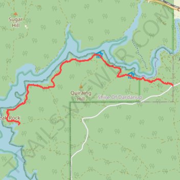
Wiilman Bilya Trail section Connell road to west
- Distance: 16.9 Km
- Elevation gain: 258 m
- Maximum elevation: 247 m
- Elevation loss: 258 m
- Minimum elevation: 171 m
- Moving time: 2 h 40 m
- Moving speed: 6.3 Km/h
- Maximum speed: 12.4 Km/h
- Total time: 2 h 42 m
- Global speed: 6.2 Km/h
Interactive trail map
Make a donation
Gear up for your next adventure:
As an Amazon Associate, this site earns from qualifying purchases at no extra cost to you.
Trail profile
- Distance: 16.9 Km
- Elevation gain: 258 m
- Maximum elevation: 247 m
- Elevation loss: 258 m
- Minimum elevation: 171 m
- Moving time: 2 h 40 m
- Moving speed: 6.3 Km/h
- Maximum speed: 12.4 Km/h
- Total time: 2 h 42 m
- Global speed: 6.2 Km/h
Make a donation
Gear up for your next adventure:
As an Amazon Associate, this site earns from qualifying purchases at no extra cost to you.
About this trail
Name: Wiilman Bilya Trail section Connell road to west trail, distance, elevation, map, profile, GPS track
Coordinates: -33.36732 116.00203 -33.34755 116.05799
Make a donation
Gear up for your next adventure:
As an Amazon Associate, this site earns from qualifying purchases at no extra cost to you.
Other hiking, mountain biking, running and outdoor activity trails
Click on a trail to view its statistics, map and profile.
Wiilman Bilya Trail Connell Road Area
Australia > Western Australia > Mungalup
Distance: 19.4 Km • Elevation gain: 450 m • Maximum elevation: 262 m
Wilman Bilya Trail
Australia > Western Australia > Collie > Mungalup
Distance: 11.9 Km • Elevation gain: 195 m • Maximum elevation: 275 m