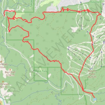
Sawtooth Ridge, Watson Lake and Lookout Mountain Loop Hike
- Distance: 28.6 Km
- Elevation gain: 961 m
- Maximum elevation: 2,449 m
- Elevation loss: 949 m
- Minimum elevation: 1,879 m
- Moving time: 4 h 29 m
- Moving speed: 6.4 Km/h
- Maximum speed: 13.5 Km/h
- Total time: 4 h 43 m
- Global speed: 6.1 Km/h
Interactive trail map
Trail profile
- Distance: 28.6 Km
- Elevation gain: 961 m
- Maximum elevation: 2,449 m
- Elevation loss: 949 m
- Minimum elevation: 1,879 m
- Moving time: 4 h 29 m
- Moving speed: 6.4 Km/h
- Maximum speed: 13.5 Km/h
- Total time: 4 h 43 m
- Global speed: 6.1 Km/h
About this trail
Name: Sawtooth Ridge, Watson Lake and Lookout Mountain Loop Hike trail, distance, elevation, map, profile, GPS track
Start: Big Chief Trail (Lower), Placer County, California, United States (39.26948 -120.20035)
End: Sawtooth Road, Placer County, California, United States (39.26924 -120.19832)
Coordinates: 39.22568 -120.20051 39.27436 -120.13320
Other hiking, mountain biking, running and outdoor activity trails
Click on a trail to view its statistics, map and profile.
Northstar bike path
United States > California > Nevada County > Truckee
Distance: 43.1 Km • Elevation gain: 886 m • Maximum elevation: 2,400 m
Northstar California Loop Run
United States > California > Placer County
Distance: 15.7 Km • Elevation gain: 654 m • Maximum elevation: 2,400 m