Make a donation
Gear up for your next adventure:
As an Amazon Associate, this site earns from qualifying purchases at no extra cost to you.
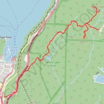
West Knob and Whyte Lake
Hike to West Knob and Whyte Lake via Baden Powel Trail, Whyte Lake Trail, Rock Pile, Donut Rock Trail and West Knob Access in the Whyte Lake Park and the Cypress Provincial Park. #Hiking #Mountain #Lake #Nature #Forest #Park
- Distance: 11.5 Km
- Elevation gain: 716 m
- Maximum elevation: 720 m
- Elevation loss: 712 m
- Minimum elevation: 73 m
- Moving time: 3 h 53 m
- Moving speed: 2.9 Km/h
- Maximum speed: 14.2 Km/h
- Total time: 5 h 15 m
- Global speed: 2.2 Km/h
Interactive trail map
Make a donation
Gear up for your next adventure:
As an Amazon Associate, this site earns from qualifying purchases at no extra cost to you.
Trail profile
- Distance: 11.5 Km
- Elevation gain: 716 m
- Maximum elevation: 720 m
- Elevation loss: 712 m
- Minimum elevation: 73 m
- Moving time: 3 h 53 m
- Moving speed: 2.9 Km/h
- Maximum speed: 14.2 Km/h
- Total time: 5 h 15 m
- Global speed: 2.2 Km/h
Make a donation
Gear up for your next adventure:
As an Amazon Associate, this site earns from qualifying purchases at no extra cost to you.
About this trail
Name: West Knob and Whyte Lake trail, distance, elevation, map, profile, GPS track
Coordinates: 49.36688 -123.27518 49.38781 -123.24092
Topography: West Vancouver topographic map, elevation, terrain
Make a donation
Gear up for your next adventure:
As an Amazon Associate, this site earns from qualifying purchases at no extra cost to you.
Other hiking, mountain biking, running and outdoor activity trails
Click on a trail to view its statistics, map and profile.