
Wildcat Mountain and Indian Hill Loop
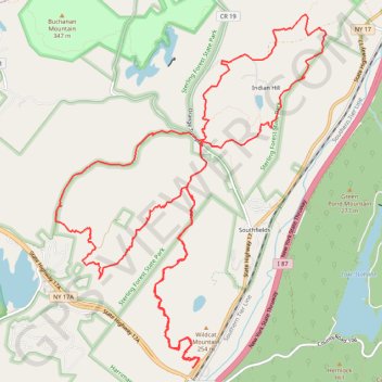
Starting at the Tuxedo Park and Ride above the Ramapo Valley, the route climbs out of Southfields on the Wildcat Mountain Trail, passes the wooded shoulder of Wildcat Mountain, and threads a quiet ridge corridor between Harriman State Park and Sterling Forest State Park before bending toward Townsend Trail and Hall Drive.
It then crosses into the Indian Hill sector, where the Furnace Loop and Indian Hill Loop add the most varied scenery: old forest roads, stone walls, a small pond, a cascading creek, historic furnace remains, rocky ledges, and views over Sterling Forest, the Ramapo River Valley, and the Harriman hills.
The return follows Hickory Hollow Road and Radio Road through mixed hardwood forest and rolling terrain, reconnecting the northern loop with the Wildcat Mountain approach for a broad, wild-feeling circuit that alternates between ridge walking, heritage traces, and enclosed woodland.
#Hiking #Loop #Mountain #Nature #Forest #Park #Woodland
- Distance: 20.1 Km
- Elevation gain: 736 m
- Maximum elevation: 327 m
- Elevation loss: 735 m
- Minimum elevation: 156 m
- Moving time: 6 h 22 m
- Moving speed: 3.2 Km/h
- Maximum speed: 21.9 Km/h
- Total time: 8 h 16 m
- Global speed: 2.4 Km/h
Interactive trail map
Trail profile
- Distance: 20.1 Km
- Elevation gain: 736 m
- Maximum elevation: 327 m
- Elevation loss: 735 m
- Minimum elevation: 156 m
- Moving time: 6 h 22 m
- Moving speed: 3.2 Km/h
- Maximum speed: 21.9 Km/h
- Total time: 8 h 16 m
- Global speed: 2.4 Km/h
About this trail
Name: Wildcat Mountain and Indian Hill Loop trail, distance, elevation, map, profile, GPS track
Coordinates: 41.22992 -74.20374 41.26791 -74.16512