Thank you for supporting this site ❤️
Make a donation
Make a donation
Gear up for your next adventure:
As an Amazon Associate, this site earns from qualifying purchases at no extra cost to you.
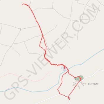
Ffynnon Gybi walk
- Distance: 2.5 Km
- Elevation gain: 125 m
- Maximum elevation: 220 m
- Elevation loss: 125 m
- Minimum elevation: 99 m
- Moving time: 58 m 22 s
- Moving speed: 2.6 Km/h
- Maximum speed: 5.3 Km/h
- Total time: 1 h 52 m
- Global speed: 1.3 Km/h
Interactive trail map
Thank you for supporting this site ❤️
Make a donation
Make a donation
Gear up for your next adventure:
As an Amazon Associate, this site earns from qualifying purchases at no extra cost to you.
Trail profile
- Distance: 2.5 Km
- Elevation gain: 125 m
- Maximum elevation: 220 m
- Elevation loss: 125 m
- Minimum elevation: 99 m
- Moving time: 58 m 22 s
- Moving speed: 2.6 Km/h
- Maximum speed: 5.3 Km/h
- Total time: 1 h 52 m
- Global speed: 1.3 Km/h
Thank you for supporting this site ❤️
Make a donation
Make a donation
Gear up for your next adventure:
As an Amazon Associate, this site earns from qualifying purchases at no extra cost to you.
About this trail
Name: Ffynnon Gybi walk trail, distance, elevation, map, profile, GPS track
Start: B4354, Llanystumdwy, Llanarmon, Gwynedd, Wales, LL53 6PR, United Kingdom (52.94373 -4.34269)
End: Llanystumdwy, Llangybi, Gwynedd, Wales, LL53 6DQ, United Kingdom (52.94371 -4.34266)
Coordinates: 52.94326 -4.34730 52.95033 -4.34003
Thank you for supporting this site ❤️
Make a donation
Make a donation
Gear up for your next adventure:
As an Amazon Associate, this site earns from qualifying purchases at no extra cost to you.