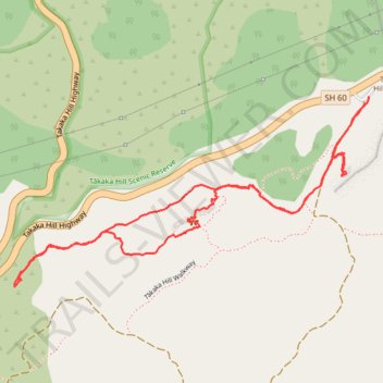
Takaka Hill Via Ferrata
- Distance: 2.7 Km
- Elevation gain: 139 m
- Maximum elevation: 887 m
- Elevation loss: 138 m
- Minimum elevation: 797 m
- Moving time: 1 h 1 m
- Moving speed: 2.7 Km/h
- Maximum speed: 5.0 Km/h
- Total time: 3 h 48 m
- Global speed: 0.7 Km/h
Interactive trail map
Trail profile
- Distance: 2.7 Km
- Elevation gain: 139 m
- Maximum elevation: 887 m
- Elevation loss: 138 m
- Minimum elevation: 797 m
- Moving time: 1 h 1 m
- Moving speed: 2.7 Km/h
- Maximum speed: 5.0 Km/h
- Total time: 3 h 48 m
- Global speed: 0.7 Km/h
About this trail
Name: Takaka Hill Via Ferrata trail, distance, elevation, map, profile, GPS track
Start: Takaka Hill Highway, New Zealand (-41.03094 172.86681)
End: 1647, Takaka Hill Highway, New Zealand (-41.03080 172.86684)
Coordinates: -41.03495 172.85661 -41.03080 172.86684
Other hiking, mountain biking, running and outdoor activity trails
Click on a trail to view its statistics, map and profile.