Thank you for supporting this site ❤️
Make a donation
Make a donation
Gear up for your next adventure:
As an Amazon Associate, this site earns from qualifying purchases at no extra cost to you.
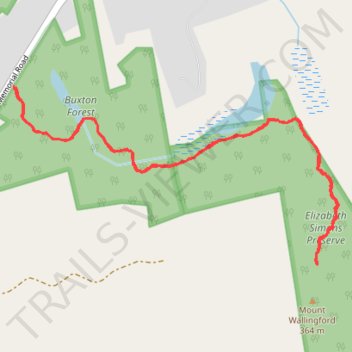
Mount Wallingford Trail gps track
- Distance: 4.5 Km
- Elevation gain: 184 m
- Maximum elevation: 356 m
- Elevation loss: 184 m
- Minimum elevation: 227 m
- Moving time: 1 h 13 m
- Moving speed: 3.7 Km/h
- Maximum speed: 6.1 Km/h
- Total time: 1 h 27 m
- Global speed: 3.1 Km/h
Interactive trail map
Thank you for supporting this site ❤️
Make a donation
Make a donation
Gear up for your next adventure:
As an Amazon Associate, this site earns from qualifying purchases at no extra cost to you.
Trail profile
- Distance: 4.5 Km
- Elevation gain: 184 m
- Maximum elevation: 356 m
- Elevation loss: 184 m
- Minimum elevation: 227 m
- Moving time: 1 h 13 m
- Moving speed: 3.7 Km/h
- Maximum speed: 6.1 Km/h
- Total time: 1 h 27 m
- Global speed: 3.1 Km/h
Thank you for supporting this site ❤️
Make a donation
Make a donation
Gear up for your next adventure:
As an Amazon Associate, this site earns from qualifying purchases at no extra cost to you.
About this trail
Name: Mount Wallingford Trail gps track trail, distance, elevation, map, profile, GPS track
Coordinates: 43.07472 -71.74941 43.08121 -71.73318
Thank you for supporting this site ❤️
Make a donation
Make a donation
Gear up for your next adventure:
As an Amazon Associate, this site earns from qualifying purchases at no extra cost to you.