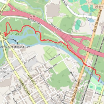
Rocky Mount Greenway: Battle Park to Martin Luther King Park
- Distance: 4.7 Km
- Elevation gain: 34 m
- Maximum elevation: 37 m
- Elevation loss: 34 m
- Minimum elevation: 20 m
- Moving time: 58 m 38 s
- Moving speed: 4.8 Km/h
- Maximum speed: 7.0 Km/h
- Total time: 58 m 38 s
- Global speed: 4.8 Km/h
Interactive trail map
Trail profile
- Distance: 4.7 Km
- Elevation gain: 34 m
- Maximum elevation: 37 m
- Elevation loss: 34 m
- Minimum elevation: 20 m
- Moving time: 58 m 38 s
- Moving speed: 4.8 Km/h
- Maximum speed: 7.0 Km/h
- Total time: 58 m 38 s
- Global speed: 4.8 Km/h
About this trail
Name: Rocky Mount Greenway: Battle Park to Martin Luther King Park trail, distance, elevation, map, profile, GPS track
Coordinates: 35.95491 -77.80475 35.96308 -77.78818
Other hiking, mountain biking, running and outdoor activity trails
Click on a trail to view its statistics, map and profile.
Rocky Mount Tar River and Parks
United States > North Carolina > Nash County > Rocky Mount
Distance: 6.4 Km • Elevation gain: 32 m • Maximum elevation: 34 m
Battle Park Loop
United States > North Carolina > Nash County > Rocky Mount > Swelton Heights
Distance: 6.3 Km • Elevation gain: 38 m • Maximum elevation: 37 m
Battle Park Loop
United States > North Carolina > Nash County > Rocky Mount > Swelton Heights
Distance: 3.9 Km • Elevation gain: 28 m • Maximum elevation: 36 m