
Woodlands Conservatory Loop Trail in New Orleans
The Woodlands Conservancy Loop Trail offers a serene hike through lush wetlands and forested areas, allowing visitors to immerse themselves in local wildlife and native vegetation. The trail winds through hardwood forests and scenic waterways, providing opportunities to observe a variety of birds and other wildlife. One of the unique highlights is a glimpse of historic World War II ammunition magazines, tucked away toward the end of the trail, blending nature with history. #Hiking #Loop #Forest #Nature
- Distance: 8.3 Km
- Elevation gain: 8 m
- Maximum elevation: 4 m
- Elevation loss: 9 m
- Minimum elevation: -1 m
- Moving time: 2 h 20 m
- Moving speed: 3.6 Km/h
- Maximum speed: 8.1 Km/h
- Total time: 2 h 34 m
- Global speed: 3.2 Km/h
Interactive trail map
Trail profile
- Distance: 8.3 Km
- Elevation gain: 8 m
- Maximum elevation: 4 m
- Elevation loss: 9 m
- Minimum elevation: -1 m
- Moving time: 2 h 20 m
- Moving speed: 3.6 Km/h
- Maximum speed: 8.1 Km/h
- Total time: 2 h 34 m
- Global speed: 3.2 Km/h
About this trail
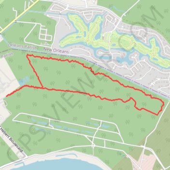
Name: Woodlands Conservatory Loop Trail in New Orleans trail, distance, elevation, map, profile, GPS track
Start: Belle Chasse, Plaquemines Parish, Louisiana, 70131, United States (29.89597 -89.97344)
End: Belle Chasse, Plaquemines Parish, Louisiana, 70131, United States (29.89580 -89.97378)
Coordinates: 29.89254 -89.97378 29.90302 -89.94226