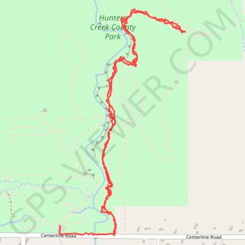
Wales NY: Hunters Creek County Park south part of eastern Orange Trail
Trail, park, Hunters Creek
- Distance: 6.3 Km
- Elevation gain: 107 m
- Maximum elevation: 354 m
- Elevation loss: 115 m
- Minimum elevation: 322 m
Interactive trail map
Trail profile
- Distance: 6.3 Km
- Elevation gain: 107 m
- Maximum elevation: 354 m
- Elevation loss: 115 m
- Minimum elevation: 322 m
About this trail
Name: Wales NY: Hunters Creek County Park south part of eastern Orange Trail trail, distance, elevation, map, profile, GPS track
Coordinates: 42.73629 -78.55132 42.74994 -78.54098