Thank you for supporting this site ❤️
Make a donation
Make a donation
Gear up for your next adventure:
As an Amazon Associate, this site earns from qualifying purchases at no extra cost to you.
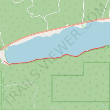
McGregor Shoreline Trail
- Distance: 3.5 Km
- Elevation gain: 35 m
- Maximum elevation: 1,202 m
- Elevation loss: 39 m
- Minimum elevation: 1,189 m
- Moving time: 51 m 13 s
- Moving speed: 4.0 Km/h
- Maximum speed: 9.1 Km/h
- Total time: 53 m 21 s
- Global speed: 3.9 Km/h
Interactive trail map
Thank you for supporting this site ❤️
Make a donation
Make a donation
Gear up for your next adventure:
As an Amazon Associate, this site earns from qualifying purchases at no extra cost to you.
Trail profile
- Distance: 3.5 Km
- Elevation gain: 35 m
- Maximum elevation: 1,202 m
- Elevation loss: 39 m
- Minimum elevation: 1,189 m
- Moving time: 51 m 13 s
- Moving speed: 4.0 Km/h
- Maximum speed: 9.1 Km/h
- Total time: 53 m 21 s
- Global speed: 3.9 Km/h
Thank you for supporting this site ❤️
Make a donation
Make a donation
Gear up for your next adventure:
As an Amazon Associate, this site earns from qualifying purchases at no extra cost to you.
About this trail
Name: McGregor Shoreline Trail trail, distance, elevation, map, profile, GPS track
Start: National Forest Development Road 6770, Flathead County, Montana, United States (48.03132 -114.90183)
End: Flathead County, Montana, United States (48.03573 -114.85912)
Coordinates: 48.03043 -114.90183 48.03573 -114.85912
Thank you for supporting this site ❤️
Make a donation
Make a donation
Gear up for your next adventure:
As an Amazon Associate, this site earns from qualifying purchases at no extra cost to you.