Point Reyes National Seashore
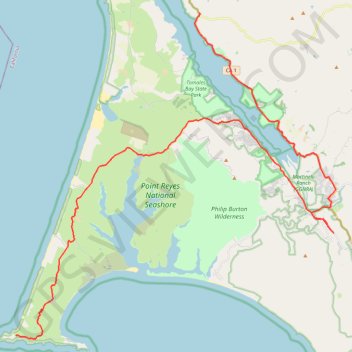
Point Reyes, Route 1 to Lighthouse
- Distance: 51.9 Km
- Elevation gain: 821 m
- Maximum elevation: 154 m
- Elevation loss: 693 m
- Minimum elevation: -1 m
Interactive trail map
Trail profile
- Distance: 51.9 Km
- Elevation gain: 821 m
- Maximum elevation: 154 m
- Elevation loss: 693 m
- Minimum elevation: -1 m
About this trail
Name: Point Reyes National Seashore trail, distance, elevation, map, profile, GPS track
Coordinates: 37.99603 -123.01231 38.16506 -122.80147
Other hiking, mountain biking, running and outdoor activity trails
Click on a trail to view its statistics, map and profile.
Arch Rock Loop via Glen Trail, Coast Trail and Bear Valley Trail
United States > California > Marin County
Starting from Glen Campground, this loop leaves the quiet backcountry camp area on the Glen Trail, crossing wooded ridges, small drainages, coastal scrub and open grassy slopes before bending westward toward the exposed Pacific side of Point Reyes National Seashore. The route then follows the Coast Trail…
Distance: 9.6 Km • Elevation gain: 347 m • Maximum elevation: 245 m
Point Reyes Loop
United States > California > Marin County > Mill Valley
Distance: 100.3 Km • Elevation gain: 1,900 m • Maximum elevation: 236 m