Thank you for supporting this site ❤️
Make a donation
Make a donation
Gear up for your next adventure:
As an Amazon Associate, this site earns from qualifying purchases at no extra cost to you.
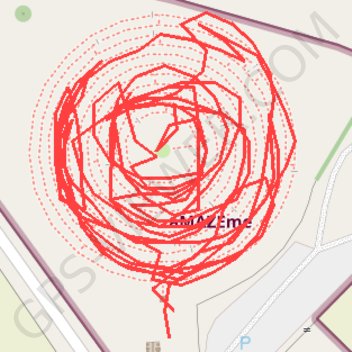
AMAZEme
- Distance: 1.5 Km
- Elevation gain: 12 m
- Maximum elevation: 310 m
- Elevation loss: 12 m
- Minimum elevation: 306 m
- Moving time: 31 m 20 s
- Moving speed: 2.9 Km/h
- Maximum speed: 10.0 Km/h
- Total time: 39 m 21 s
- Global speed: 2.3 Km/h
Interactive trail map
Thank you for supporting this site ❤️
Make a donation
Make a donation
Gear up for your next adventure:
As an Amazon Associate, this site earns from qualifying purchases at no extra cost to you.
Trail profile
- Distance: 1.5 Km
- Elevation gain: 12 m
- Maximum elevation: 310 m
- Elevation loss: 12 m
- Minimum elevation: 306 m
- Moving time: 31 m 20 s
- Moving speed: 2.9 Km/h
- Maximum speed: 10.0 Km/h
- Total time: 39 m 21 s
- Global speed: 2.3 Km/h
Thank you for supporting this site ❤️
Make a donation
Make a donation
Gear up for your next adventure:
As an Amazon Associate, this site earns from qualifying purchases at no extra cost to you.
About this trail
Name: AMAZEme trail, distance, elevation, map, profile, GPS track
Coordinates: -38.08856 176.19428 -38.08795 176.19485
Thank you for supporting this site ❤️
Make a donation
Make a donation
Gear up for your next adventure:
As an Amazon Associate, this site earns from qualifying purchases at no extra cost to you.