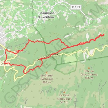
Malaucene
- Distance: 14.7 Km
- Elevation gain: 667 m
- Maximum elevation: 765 m
- Elevation loss: 671 m
- Minimum elevation: 378 m
Interactive trail map
Trail profile
- Distance: 14.7 Km
- Elevation gain: 667 m
- Maximum elevation: 765 m
- Elevation loss: 671 m
- Minimum elevation: 378 m
About this trail
Name: Malaucene trail, distance, elevation, map, profile, GPS track
Coordinates: 44.15880 5.14105 44.17579 5.20142
Other hiking, mountain biking, running and outdoor activity trails
Click on a trail to view its statistics, map and profile.
1 LUCENA - MONTPELLIER
Distance: 2,964.4 Km • Elevation gain: 29,500 m • Maximum elevation: 1,048 m
PT23DS2 Lörrach → Cadaqués
Germany > Baden-Württemberg > Landkreis Lörrach > Lörrach (Kernstadt)
Distance: 1,050.7 Km • Elevation gain: 13,130 m • Maximum elevation: 1,505 m
Chemin de Saint-Jacques-de-Compostelle
Switzerland > Geneva > Geneva
Distance: 1,117.8 Km • Elevation gain: 25,262 m • Maximum elevation: 1,430 m
Mont Ventoux - all 3 sides
France > Provence-Alpes-Côte d'Azur > Vaucluse > Bédoin
Distance: 132.4 Km • Elevation gain: 4,505 m • Maximum elevation: 1,897 m