Thank you for supporting this site ❤️
Make a donation
Make a donation
Gear up for your next adventure:
As an Amazon Associate, this site earns from qualifying purchases at no extra cost to you.
University of New Hampshire College woods bike
- Distance: 6.3 Km
- Elevation gain: 72 m
- Maximum elevation: 36 m
- Elevation loss: 71 m
- Minimum elevation: 12 m
- Moving time: 25 m 20 s
- Moving speed: 15.0 Km/h
- Maximum speed: 43.5 Km/h
- Total time: 26 m 51 s
- Global speed: 14.2 Km/h
Interactive trail map
Thank you for supporting this site ❤️
Make a donation
Make a donation
Gear up for your next adventure:
As an Amazon Associate, this site earns from qualifying purchases at no extra cost to you.
Trail profile
- Distance: 6.3 Km
- Elevation gain: 72 m
- Maximum elevation: 36 m
- Elevation loss: 71 m
- Minimum elevation: 12 m
- Moving time: 25 m 20 s
- Moving speed: 15.0 Km/h
- Maximum speed: 43.5 Km/h
- Total time: 26 m 51 s
- Global speed: 14.2 Km/h
Thank you for supporting this site ❤️
Make a donation
Make a donation
Gear up for your next adventure:
As an Amazon Associate, this site earns from qualifying purchases at no extra cost to you.
About this trail
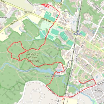
Name: University of New Hampshire College woods bike trail, distance, elevation, map, profile, GPS track
Coordinates: 43.12807 -70.95178 43.14380 -70.93190
Thank you for supporting this site ❤️
Make a donation
Make a donation
Gear up for your next adventure:
As an Amazon Associate, this site earns from qualifying purchases at no extra cost to you.
Other hiking, mountain biking, running and outdoor activity trails
Click on a trail to view its statistics, map and profile.
2026-06-23_11-48_Tue
United States > New Hampshire > Hillsborough County > Goffstown > Grasmere
Distance: 70.3 Km • Elevation gain: 643 m • Maximum elevation: 140 m