Thank you for supporting this site ❤️
Make a donation
Make a donation
Gear up for your next adventure:
As an Amazon Associate, this site earns from qualifying purchases at no extra cost to you.
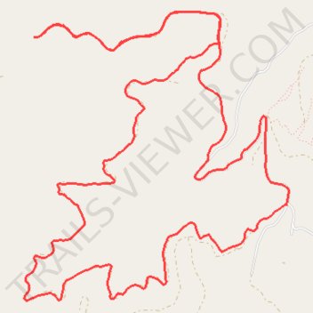
Dry creek
- Distance: 14.4 Km
- Elevation gain: 606 m
- Maximum elevation: 1,428 m
- Elevation loss: 606 m
- Minimum elevation: 1,130 m
- Moving time: 1 h 20 m
- Moving speed: 10.7 Km/h
- Maximum speed: 35.6 Km/h
- Total time: 1 h 35 m
- Global speed: 9.0 Km/h
Interactive trail map
Thank you for supporting this site ❤️
Make a donation
Make a donation
Gear up for your next adventure:
As an Amazon Associate, this site earns from qualifying purchases at no extra cost to you.
Trail profile
- Distance: 14.4 Km
- Elevation gain: 606 m
- Maximum elevation: 1,428 m
- Elevation loss: 606 m
- Minimum elevation: 1,130 m
- Moving time: 1 h 20 m
- Moving speed: 10.7 Km/h
- Maximum speed: 35.6 Km/h
- Total time: 1 h 35 m
- Global speed: 9.0 Km/h
Thank you for supporting this site ❤️
Make a donation
Make a donation
Gear up for your next adventure:
As an Amazon Associate, this site earns from qualifying purchases at no extra cost to you.
About this trail
Name: Dry creek trail, distance, elevation, map, profile, GPS track
Start: Dry Gulch Road, Missoula County, Montana, United States (46.91233 -114.22451)
End: Dry Gulch Road, Missoula County, Montana, United States (46.91231 -114.22459)
Coordinates: 46.90205 -114.24391 46.92281 -114.21612
Thank you for supporting this site ❤️
Make a donation
Make a donation
Gear up for your next adventure:
As an Amazon Associate, this site earns from qualifying purchases at no extra cost to you.