Desert challenge 24
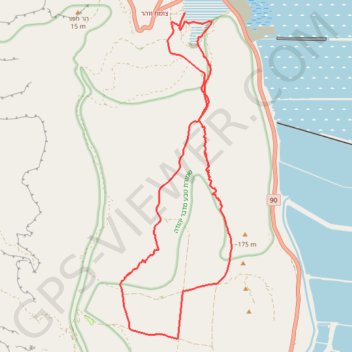
- Distance: 23.1 Km
- Elevation gain: 308 m
- Maximum elevation: -221 m
- Elevation loss: 309 m
- Minimum elevation: -383 m
- Moving time: 1 h 1 m
- Moving speed: 22.6 Km/h
- Maximum speed: 45.9 Km/h
- Total time: 1 h 1 m
- Global speed: 22.6 Km/h
Interactive trail map
Trail profile
- Distance: 23.1 Km
- Elevation gain: 308 m
- Maximum elevation: -221 m
- Elevation loss: 309 m
- Minimum elevation: -383 m
- Moving time: 1 h 1 m
- Moving speed: 22.6 Km/h
- Maximum speed: 45.9 Km/h
- Total time: 1 h 1 m
- Global speed: 22.6 Km/h
About this trail
Name: Desert challenge 24 trail, distance, elevation, map, profile, GPS track
Start: 90, Tamar Regional Council, Beersheba Subdistrict, South District, Israel (31.14114 35.36778)
End: 90, Tamar Regional Council, Beersheba Subdistrict, South District, Israel (31.14115 35.36761)
Coordinates: 31.06822 35.35098 31.14147 35.38030