Make a donation
Gear up for your next adventure:
As an Amazon Associate, this site earns from qualifying purchases at no extra cost to you.
Komoka Provincial Park
Interactive trail map
Make a donation
Gear up for your next adventure:
As an Amazon Associate, this site earns from qualifying purchases at no extra cost to you.
Trail profile
- Distance: 7.8 Km
- Elevation gain: 99 m
- Maximum elevation: 271 m
- Elevation loss: 99 m
- Minimum elevation: 217 m
Make a donation
Gear up for your next adventure:
As an Amazon Associate, this site earns from qualifying purchases at no extra cost to you.
About this trail
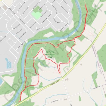
Name: Komoka Provincial Park trail, distance, elevation, map, profile, GPS track
Start: Blue Trail, Middlesex Centre, Middlesex County, Ontario, N0L 1R0, Canada (42.94557 -81.39365)
End: Blue Trail, Middlesex Centre, Middlesex County, Ontario, N0L 1R0, Canada (42.94557 -81.39365)
Coordinates: 42.93967 -81.40516 42.95960 -81.38598
Topography: Middlesex Centre topographic map, elevation, terrain
Make a donation
Gear up for your next adventure:
As an Amazon Associate, this site earns from qualifying purchases at no extra cost to you.