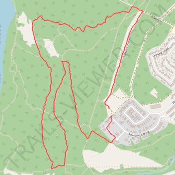
Cousin Bugle Loop
- Distance: 6.1 Km
- Elevation gain: 186 m
- Maximum elevation: 1,220 m
- Elevation loss: 180 m
- Minimum elevation: 1,071 m
- Moving time: 1 h 17 m
- Moving speed: 4.7 Km/h
- Maximum speed: 15.4 Km/h
- Total time: 1 h 18 m
- Global speed: 4.7 Km/h
Interactive trail map
Trail profile
- Distance: 6.1 Km
- Elevation gain: 186 m
- Maximum elevation: 1,220 m
- Elevation loss: 180 m
- Minimum elevation: 1,071 m
- Moving time: 1 h 17 m
- Moving speed: 4.7 Km/h
- Maximum speed: 15.4 Km/h
- Total time: 1 h 18 m
- Global speed: 4.7 Km/h
About this trail
Name: Cousin Bugle Loop trail, distance, elevation, map, profile, GPS track
Coordinates: 53.87140 -119.15990 53.88421 -119.14505
Topography: Municipal District of Greenview topographic map, elevation, terrain
Other hiking, mountain biking, running and outdoor activity trails
Click on a trail to view its statistics, map and profile.
Grande Cache Old Canoe Viewpoint Loop via Great Escape, OG Rim Trail and Sulphur Slide
Canada > Alberta > Municipal District of Greenview > Hamlet of Grande Cache
Distance: 14.3 Km • Elevation gain: 454 m • Maximum elevation: 1,211 m
Great Escape, Rabbit's Foot, Shady Past, Old Canoe, Sulphur Slide and Creek 2 Peak loop trails
Canada > Alberta > Municipal District of Greenview > Hamlet of Grande Cache
Afternoon Mountain Bike Ride
Distance: 10.0 Km • Elevation gain: 214 m • Maximum elevation: 1,220 m
Grande Cache Ginger Princess and Bucksaw Ridge Loop Trail
Canada > Alberta > Municipal District of Greenview > Hamlet of Grande Cache
Distance: 11.1 Km • Elevation gain: 254 m • Maximum elevation: 1,209 m
Loop hike to Anton's Viewpoint
Canada > Alberta > Municipal District of Greenview > Hamlet of Grande Cache
Via Jumeau's Stretch, Hufflepuff, Phoenix, Cul de Sac, Hagrids, Mother Daughter Bonding, Fun Uncle Buck and Griffith trails.
Distance: 7.2 Km • Elevation gain: 265 m • Maximum elevation: 1,213 m
Grande Cache Loop Trail
Canada > Alberta > Municipal District of Greenview > Hamlet of Grande Cache
Distance: 9.8 Km • Elevation gain: 293 m • Maximum elevation: 1,248 m
Great Escape Loop Trail
Canada > Alberta > Municipal District of Greenview > Hamlet of Grande Cache
Distance: 8.6 Km • Elevation gain: 194 m • Maximum elevation: 1,211 m