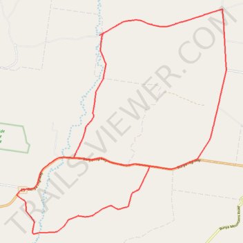
Boyneside and Mannuem
- Distance: 36.5 Km
- Elevation gain: 419 m
- Maximum elevation: 651 m
- Elevation loss: 419 m
- Minimum elevation: 479 m
- Moving time: 2 h 4 m
- Moving speed: 17.5 Km/h
- Maximum speed: 59.1 Km/h
- Total time: 2 h 44 m
- Global speed: 13.3 Km/h
Interactive trail map
Trail profile
- Distance: 36.5 Km
- Elevation gain: 419 m
- Maximum elevation: 651 m
- Elevation loss: 419 m
- Minimum elevation: 479 m
- Moving time: 2 h 4 m
- Moving speed: 17.5 Km/h
- Maximum speed: 59.1 Km/h
- Total time: 2 h 44 m
- Global speed: 13.3 Km/h
About this trail
Name: Boyneside and Mannuem trail, distance, elevation, map, profile, GPS track
Start: Ironpot Road, Mannuem, South Burnett Regional, Queensland, Australia (-26.67020 151.56138)
End: Ironpot Road, Mannuem, South Burnett Regional, Queensland, Australia (-26.67025 151.56135)
Coordinates: -26.74270 151.52639 -26.66139 151.61122
Other hiking, mountain biking, running and outdoor activity trails
Click on a trail to view its statistics, map and profile.
Chahpingah to Kumbia
Ironpot Road
Distance: 48.0 Km • Elevation gain: 732 m • Maximum elevation: 554 m