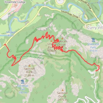
Glacier Point via Four Mile Trail in Yosemite National Park
Hiking the Four-Mile Trail to Glacier Point offers some of the best views in Yosemite National Park, with expansive vistas unfolding gradually as you ascend. Along the way, hikers can admire iconic landmarks like Yosemite Falls, El Capitan, and Half Dome, as well as the deep reaches of Tenaya Canyon. Though the trail is strenuous, the sweeping panoramic views, including sights of North Dome and the Royal Arches, make the effort rewarding. Whether taking in the scenery from Union Point or reaching the final destination at Glacier Point, the trail offers a mix of natural beauty and historic charm that makes it a must-do for serious hikers. #Hiking #Mountain #Forest #Overlook #Nature #Yosemite
- Distance: 7.6 Km
- Elevation gain: 1,254 m
- Maximum elevation: 2,208 m
- Elevation loss: 267 m
- Minimum elevation: 1,219 m
Interactive trail map
Trail profile
- Distance: 7.6 Km
- Elevation gain: 1,254 m
- Maximum elevation: 2,208 m
- Elevation loss: 267 m
- Minimum elevation: 1,219 m
About this trail
Name: Glacier Point via Four Mile Trail in Yosemite National Park trail, distance, elevation, map, profile, GPS track
Coordinates: 37.72749 -119.60223 37.73693 -119.57308
Other hiking, mountain biking, running and outdoor activity trails
Click on a trail to view its statistics, map and profile.
Sentinel Dome, Glacier Point, Union Point and Taft Point Loop (Yosemite)
United States > California > Mariposa County
From Sentinel Dome Trailhead, the loop begins among conifer forest, meadow and open granite before climbing toward Sentinel Dome, where the landscape opens to broad views over Yosemite Valley, Half Dome and the high Sierra. The route then swings toward Glacier Point, one of Yosemite’s classic overlooks above…
Distance: 21.5 Km • Elevation gain: 1,776 m • Maximum elevation: 2,478 m
Glacier Point
United States > California > Mariposa County > Curry Village
Starting at Four Mile Trailhead in Yosemite Valley, the route joins the Four Mile Trail and begins its steady climb from the valley floor above the Merced River corridor. It first rises through forested slopes near Sentinel Creek, with early views opening toward Sentinel Rock and the meadows of Yosemite…
Distance: 7.7 Km • Elevation gain: 1,250 m • Maximum elevation: 2,197 m
Yosemite Valley Loop
United States > California > Mariposa County > Yosemite Village
From Yosemite Village, the route slips into the Valley Loop Trail corridor, moving through the quieter village edge toward Yosemite Falls views before continuing west below the Three Brothers and into the open floor of Leidig Meadow, where forest, meadow grass, and the Merced River alternate along the way. The…
Distance: 14.9 Km • Elevation gain: 213 m • Maximum elevation: 1,240 m
Glacier Point and Union Point via Four Mile Trail
United States > California > Mariposa County > Yosemite Village > Yosemite Lodge
From Yosemite Valley, the Four Mile Trail climbs away from the Merced River through forested slopes and long switchbacks on the south wall of the valley, steadily opening views toward Sentinel Rock, El Capitan, Yosemite Falls, and the granite cliffs that frame the valley floor. Higher on the route, the path…
Distance: 15.2 Km • Elevation gain: 1,647 m • Maximum elevation: 2,197 m
Four Mile Trail in Yosemite National Park
United States > California > Mariposa County > Yosemite Village > Yosemite Lodge
The Four Mile Trail in Yosemite National Park provides hikers with a challenging yet rewarding experience. As you ascend the trail, you'll be treated to ever-changing views of Yosemite Valley, including dramatic overlooks of Yosemite Falls, El Capitan, and Bridalveil Fall, with distant glimpses of the Sierra…
Distance: 16.6 Km • Elevation gain: 1,604 m • Maximum elevation: 2,197 m
Four Mile Trail to Glacier Point and Union Point in Yosemite National Park
United States > California > Mariposa County > Yosemite Village > Yosemite Lodge
The Four Mile Trail in Yosemite National Park offers hikers a strenuous ascent from Yosemite Valley to Glacier Point, providing panoramic views of iconic landmarks. Along the route, hikers can observe the grandeur of El Capitan and Yosemite Falls, the expansive vistas of Yosemite Valley, and the impressive…
Distance: 16.0 Km • Elevation gain: 1,673 m • Maximum elevation: 2,197 m
Ledge Trail to Glacier Point
United States > California > Mariposa County > Curry Village
Mariposa County Hiking
Distance: 4.2 Km • Elevation gain: 1,443 m • Maximum elevation: 2,197 m