
Rainbow Loop Trail in Rainbow Mountain Preserve
The Rainbow Loop Trail offers a moderately challenging experience with a mix of rocky terrain, gentle inclines, and beautiful scenery. Hikers can enjoy sweeping views of Madison while descending into peaceful woodland areas, passing by multiple caves, springs, and diverse plant life along the way. The trail also features scenic benches perfect for resting and soaking in the surrounding natural beauty, including wildflowers and rich forested landscapes. #Hiking #Loop #Forest #Nature
- Distance: 2.5 Km
- Elevation gain: 101 m
- Maximum elevation: 340 m
- Elevation loss: 102 m
- Minimum elevation: 238 m
- Moving time: 35 m 11 s
- Moving speed: 4.2 Km/h
- Maximum speed: 10.7 Km/h
- Total time: 35 m 11 s
- Global speed: 4.2 Km/h
Interactive trail map
Trail profile
- Distance: 2.5 Km
- Elevation gain: 101 m
- Maximum elevation: 340 m
- Elevation loss: 102 m
- Minimum elevation: 238 m
- Moving time: 35 m 11 s
- Moving speed: 4.2 Km/h
- Maximum speed: 10.7 Km/h
- Total time: 35 m 11 s
- Global speed: 4.2 Km/h
About this trail
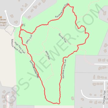
Name: Rainbow Loop Trail in Rainbow Mountain Preserve trail, distance, elevation, map, profile, GPS track
Coordinates: 34.72852 -86.72783 34.73573 -86.72171