Thank you for supporting this site ❤️
Make a donation
Make a donation
Gear up for your next adventure:
As an Amazon Associate, this site earns from qualifying purchases at no extra cost to you.
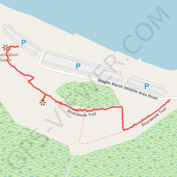
Boardwalk Trail
- Distance: 1.1 Km
- Elevation gain: 3 m
- Maximum elevation: 177 m
- Elevation loss: 4 m
- Minimum elevation: 173 m
- Moving time: 29 m 16 s
- Moving speed: 2.3 Km/h
- Maximum speed: 14.0 Km/h
- Total time: 49 m 53 s
- Global speed: 1.3 Km/h
Interactive trail map
Thank you for supporting this site ❤️
Make a donation
Make a donation
Gear up for your next adventure:
As an Amazon Associate, this site earns from qualifying purchases at no extra cost to you.
Trail profile
- Distance: 1.1 Km
- Elevation gain: 3 m
- Maximum elevation: 177 m
- Elevation loss: 4 m
- Minimum elevation: 173 m
- Moving time: 29 m 16 s
- Moving speed: 2.3 Km/h
- Maximum speed: 14.0 Km/h
- Total time: 49 m 53 s
- Global speed: 1.3 Km/h
Thank you for supporting this site ❤️
Make a donation
Make a donation
Gear up for your next adventure:
As an Amazon Associate, this site earns from qualifying purchases at no extra cost to you.
About this trail
Name: Boardwalk Trail trail, distance, elevation, map, profile, GPS track
End: Boardwalk Trail, Lucas County, Ohio, United States (41.62920 -83.19296)
Coordinates: 41.62622 -83.19351 41.62920 -83.18578
Thank you for supporting this site ❤️
Make a donation
Make a donation
Gear up for your next adventure:
As an Amazon Associate, this site earns from qualifying purchases at no extra cost to you.