Make a donation
Gear up for your next adventure:
As an Amazon Associate, this site earns from qualifying purchases at no extra cost to you.
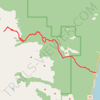
Tershishner Peak route
- Distance: 27.5 Km
- Elevation gain: 2,629 m
- Maximum elevation: 2,815 m
- Elevation loss: 2,629 m
- Minimum elevation: 1,332 m
- Moving time: 13 h 21 m
- Moving speed: 2.1 Km/h
- Maximum speed: 7.2 Km/h
- Total time: 1 d 33 m
- Global speed: 1.1 Km/h
Interactive trail map
Make a donation
Gear up for your next adventure:
As an Amazon Associate, this site earns from qualifying purchases at no extra cost to you.
Trail profile
- Distance: 27.5 Km
- Elevation gain: 2,629 m
- Maximum elevation: 2,815 m
- Elevation loss: 2,629 m
- Minimum elevation: 1,332 m
- Moving time: 13 h 21 m
- Moving speed: 2.1 Km/h
- Maximum speed: 7.2 Km/h
- Total time: 1 d 33 m
- Global speed: 1.1 Km/h
Make a donation
Gear up for your next adventure:
As an Amazon Associate, this site earns from qualifying purchases at no extra cost to you.
About this trail
Name: Tershishner Peak route trail, distance, elevation, map, profile, GPS track
Start: Highway 11, Clearwater County, Alberta, Canada (52.29146 -116.37395)
End: Highway 11, Clearwater County, Alberta, Canada (52.29146 -116.37399)
Coordinates: 52.29114 -116.48948 52.32609 -116.37395
Topography: Clearwater County topographic map, elevation, terrain
Make a donation
Gear up for your next adventure:
As an Amazon Associate, this site earns from qualifying purchases at no extra cost to you.
Other hiking, mountain biking, running and outdoor activity trails
Click on a trail to view its statistics, map and profile.
Big Stones Peak and Infinite Stones Peak traverse
Canada > Alberta > Clearwater County
Scrambling, mountain, peak
Distance: 19.7 Km • Elevation gain: 1,788 m • Maximum elevation: 2,725 m