Thank you for supporting this site ❤️
Make a donation
Make a donation
Gear up for your next adventure:
As an Amazon Associate, this site earns from qualifying purchases at no extra cost to you.
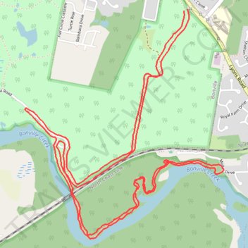
Bongil Bongil National Park
- Distance: 11.1 Km
- Elevation gain: 54 m
- Maximum elevation: 29 m
- Elevation loss: 56 m
- Minimum elevation: 2 m
- Moving time: 54 m 36 s
- Moving speed: 12.2 Km/h
- Maximum speed: 23.3 Km/h
- Total time: 54 m 36 s
- Global speed: 12.2 Km/h
Interactive trail map
Thank you for supporting this site ❤️
Make a donation
Make a donation
Gear up for your next adventure:
As an Amazon Associate, this site earns from qualifying purchases at no extra cost to you.
Trail profile
- Distance: 11.1 Km
- Elevation gain: 54 m
- Maximum elevation: 29 m
- Elevation loss: 56 m
- Minimum elevation: 2 m
- Moving time: 54 m 36 s
- Moving speed: 12.2 Km/h
- Maximum speed: 23.3 Km/h
- Total time: 54 m 36 s
- Global speed: 12.2 Km/h
Thank you for supporting this site ❤️
Make a donation
Make a donation
Gear up for your next adventure:
As an Amazon Associate, this site earns from qualifying purchases at no extra cost to you.
About this trail
Name: Bongil Bongil National Park trail, distance, elevation, map, profile, GPS track
Coordinates: -30.37961 153.06306 -30.36258 153.08014
Thank you for supporting this site ❤️
Make a donation
Make a donation
Gear up for your next adventure:
As an Amazon Associate, this site earns from qualifying purchases at no extra cost to you.
Other hiking, mountain biking, running and outdoor activity trails
Click on a trail to view its statistics, map and profile.
Bongil Picnic Area parkrun
Australia > New South Wales > Coffs Harbour
Distance: 5.1 Km • Elevation gain: 43 m • Maximum elevation: 29 m