Thank you for supporting this site ❤️
Make a donation
Make a donation
Gear up for your next adventure:
As an Amazon Associate, this site earns from qualifying purchases at no extra cost to you.
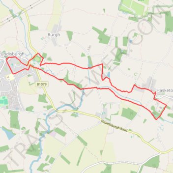
Walk - Hasketon and Grundisburgh
- Distance: 7.6 Km
- Elevation gain: 62 m
- Maximum elevation: 32 m
- Elevation loss: 62 m
- Minimum elevation: 14 m
- Moving time: 1 h 56 m
- Moving speed: 3.9 Km/h
- Maximum speed: 5.8 Km/h
- Total time: 2 h 22 m
- Global speed: 3.2 Km/h
Interactive trail map
Thank you for supporting this site ❤️
Make a donation
Make a donation
Gear up for your next adventure:
As an Amazon Associate, this site earns from qualifying purchases at no extra cost to you.
Trail profile
- Distance: 7.6 Km
- Elevation gain: 62 m
- Maximum elevation: 32 m
- Elevation loss: 62 m
- Minimum elevation: 14 m
- Moving time: 1 h 56 m
- Moving speed: 3.9 Km/h
- Maximum speed: 5.8 Km/h
- Total time: 2 h 22 m
- Global speed: 3.2 Km/h
Thank you for supporting this site ❤️
Make a donation
Make a donation
Gear up for your next adventure:
As an Amazon Associate, this site earns from qualifying purchases at no extra cost to you.
About this trail
Name: Walk - Hasketon and Grundisburgh trail, distance, elevation, map, profile, GPS track
Start: Tymmes Place, Hasketon, East Suffolk, Suffolk, England, IP13 6JD, United Kingdom (52.10756 1.28480)
End: Tymmes Place, Hasketon, East Suffolk, Suffolk, England, IP13 6JD, United Kingdom (52.10749 1.28469)
Coordinates: 52.10320 1.24630 52.11367 1.28749
Thank you for supporting this site ❤️
Make a donation
Make a donation
Gear up for your next adventure:
As an Amazon Associate, this site earns from qualifying purchases at no extra cost to you.