Thank you for supporting this site ❤️
Make a donation
Make a donation
Gear up for your next adventure:
As an Amazon Associate, this site earns from qualifying purchases at no extra cost to you.
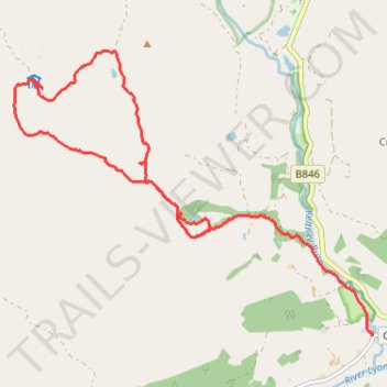
Walk to Pheiginn Bothy then traverse across snow to other track
- Distance: 10.8 Km
- Elevation gain: 296 m
- Maximum elevation: 580 m
- Elevation loss: 520 m
- Minimum elevation: 110 m
- Moving time: 2 h 16 m
- Moving speed: 4.7 Km/h
- Maximum speed: 12.7 Km/h
- Total time: 2 h 34 m
- Global speed: 4.2 Km/h
Interactive trail map
Thank you for supporting this site ❤️
Make a donation
Make a donation
Gear up for your next adventure:
As an Amazon Associate, this site earns from qualifying purchases at no extra cost to you.
Trail profile
- Distance: 10.8 Km
- Elevation gain: 296 m
- Maximum elevation: 580 m
- Elevation loss: 520 m
- Minimum elevation: 110 m
- Moving time: 2 h 16 m
- Moving speed: 4.7 Km/h
- Maximum speed: 12.7 Km/h
- Total time: 2 h 34 m
- Global speed: 4.2 Km/h
Thank you for supporting this site ❤️
Make a donation
Make a donation
Gear up for your next adventure:
As an Amazon Associate, this site earns from qualifying purchases at no extra cost to you.
About this trail
Name: Walk to Pheiginn Bothy then traverse across snow to other track trail, distance, elevation, map, profile, GPS track
Start: B846, Coshieville, Perth and Kinross, Scotland, PH15 2LG, United Kingdom (56.62900 -4.03222)
Coordinates: 56.61780 -4.05964 56.64395 -3.99999
Thank you for supporting this site ❤️
Make a donation
Make a donation
Gear up for your next adventure:
As an Amazon Associate, this site earns from qualifying purchases at no extra cost to you.