
Pedernales Falls Wolf Mountain Loop
From the Wolf Mountain trailhead, the loop enters the Hill Country woodland, crosses Regal Creek, and follows the Wolf Mountain Trail toward open views above the Pedernales River valley.
The route then bends around Tobacco Mountain and Wolf Mountain, passing rocky clearings, cedar forest, and the small canyons shaped by Mescal Creek and Tobacco Creek.
It returns through a quiet mix of limestone terrain, creeksides, and wooded slopes, making one of Pedernales Falls State Park’s classic moderate hikes.
#Hiking #Loop #Nature #Forest #Mountain #Park
- Distance: 9.4 Km
- Elevation gain: 125 m
- Maximum elevation: 327 m
- Elevation loss: 125 m
- Minimum elevation: 278 m
- Moving time: 2 h 22 m
- Moving speed: 4.0 Km/h
- Maximum speed: 7.0 Km/h
- Total time: 2 h 34 m
- Global speed: 3.6 Km/h
Interactive trail map
Trail profile
- Distance: 9.4 Km
- Elevation gain: 125 m
- Maximum elevation: 327 m
- Elevation loss: 125 m
- Minimum elevation: 278 m
- Moving time: 2 h 22 m
- Moving speed: 4.0 Km/h
- Maximum speed: 7.0 Km/h
- Total time: 2 h 34 m
- Global speed: 3.6 Km/h
About this trail
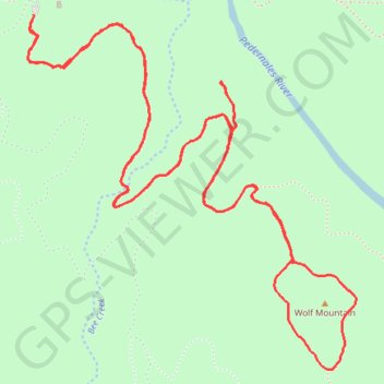
Name: Pedernales Falls Wolf Mountain Loop trail, distance, elevation, map, profile, GPS track
Start: Wolf Mountain Loop, Blanco County, Texas, United States (30.30727 -98.25563)
End: Wolf Mountain Loop, Blanco County, Texas, United States (30.30721 -98.25561)
Coordinates: 30.29236 -98.25591 30.30727 -98.23996