New
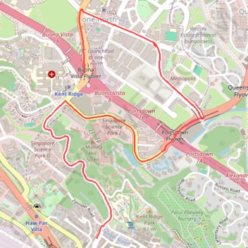
- Distance: 5.9 Km
- Elevation gain: 74 m
- Maximum elevation: 51 m
- Elevation loss: 89 m
- Minimum elevation: 11 m
Interactive trail map
Trail profile
- Distance: 5.9 Km
- Elevation gain: 74 m
- Maximum elevation: 51 m
- Elevation loss: 89 m
- Minimum elevation: 11 m
About this trail
Name: New trail, distance, elevation, map, profile, GPS track
End: 21, South Buona Vista Road, Queenstown, Southwest, Singapore, 117526, Singapore (1.28088 103.78676)
Coordinates: 1.28088 103.78243 1.29956 103.79548
Other hiking, mountain biking, running and outdoor activity trails
Click on a trail to view its statistics, map and profile.
The Green Corridor - Singapore
Distance: 22.3 Km • Elevation gain: 167 m • Maximum elevation: 44 m
Rail Corridor
Distance: 8.6 Km • Elevation gain: 111 m • Maximum elevation: 53 m
Directions from Duck Tour Ramp to Marina Boulevard, Singapore
Distance: 105.3 Km • Elevation gain: 812 m • Maximum elevation: 51 m