Caen Merville Cabourg (via Sallenelles)
- Distance: 25.9 Km
- Elevation gain: 112 m
- Maximum elevation: 17 m
- Elevation loss: 118 m
- Minimum elevation: 0 m
Interactive trail map
Trail profile
- Distance: 25.9 Km
- Elevation gain: 112 m
- Maximum elevation: 17 m
- Elevation loss: 118 m
- Minimum elevation: 0 m
About this trail
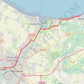
Name: Caen Merville Cabourg (via Sallenelles) trail, distance, elevation, map, profile, GPS track
Coordinates: 49.18299 -0.36470 49.29307 -0.11595
Other hiking, mountain biking, running and outdoor activity trails
Click on a trail to view its statistics, map and profile.
Bayeux-Caen short
France > Normandy > Calvados > Bayeux
Distance: 52.4 Km • Elevation gain: 405 m • Maximum elevation: 77 m
Bayeux-Caen Long
France > Normandy > Calvados > Bayeux
Distance: 64.2 Km • Elevation gain: 458 m • Maximum elevation: 77 m
Caen Beuvron Cabourg
France > Normandy > Calvados > Caen
Distance: 54.2 Km • Elevation gain: 371 m • Maximum elevation: 58 m
Caen Merville Cabourg
France > Normandy > Calvados > Caen
Distance: 27.2 Km • Elevation gain: 138 m • Maximum elevation: 58 m