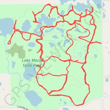
Lake Maria State Park
Wright County Running
- Distance: 32.7 Km
- Elevation gain: 290 m
- Maximum elevation: 321 m
- Elevation loss: 292 m
- Minimum elevation: 294 m
- Moving time: 6 h 56 s
- Moving speed: 5.4 Km/h
- Maximum speed: 14.1 Km/h
- Total time: 6 h 17 m
- Global speed: 5.2 Km/h
Interactive trail map
Trail profile
- Distance: 32.7 Km
- Elevation gain: 290 m
- Maximum elevation: 321 m
- Elevation loss: 292 m
- Minimum elevation: 294 m
- Moving time: 6 h 56 s
- Moving speed: 5.4 Km/h
- Maximum speed: 14.1 Km/h
- Total time: 6 h 17 m
- Global speed: 5.2 Km/h
About this trail
Name: Lake Maria State Park trail, distance, elevation, map, profile, GPS track
Coordinates: 45.30404 -93.96031 45.32580 -93.93165