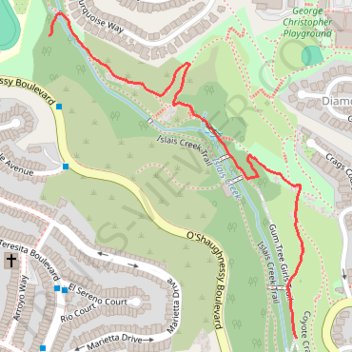
Hike in Glen Canyon Park
- Distance: 1.3 Km
- Elevation gain: 42 m
- Maximum elevation: 135 m
- Elevation loss: 79 m
- Minimum elevation: 93 m
- Moving time: 18 m 33 s
- Moving speed: 4.0 Km/h
- Maximum speed: 9.8 Km/h
- Total time: 18 m 33 s
- Global speed: 4.0 Km/h
Interactive trail map
Trail profile
- Distance: 1.3 Km
- Elevation gain: 42 m
- Maximum elevation: 135 m
- Elevation loss: 79 m
- Minimum elevation: 93 m
- Moving time: 18 m 33 s
- Moving speed: 4.0 Km/h
- Maximum speed: 9.8 Km/h
- Total time: 18 m 33 s
- Global speed: 4.0 Km/h
About this trail
Name: Hike in Glen Canyon Park trail, distance, elevation, map, profile, GPS track
Coordinates: 37.73804 -122.44642 37.74384 -122.44069