Make a donation
Gear up for your next adventure:
As an Amazon Associate, this site earns from qualifying purchases at no extra cost to you.
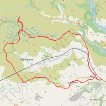
Peak District loop hike
- Distance: 36.3 Km
- Elevation gain: 846 m
- Maximum elevation: 632 m
- Elevation loss: 837 m
- Minimum elevation: 162 m
- Moving time: 7 h 44 m
- Moving speed: 4.7 Km/h
- Maximum speed: 10.9 Km/h
- Total time: 21 h 48 m
- Global speed: 1.7 Km/h
Interactive trail map
Make a donation
Gear up for your next adventure:
As an Amazon Associate, this site earns from qualifying purchases at no extra cost to you.
Trail profile
- Distance: 36.3 Km
- Elevation gain: 846 m
- Maximum elevation: 632 m
- Elevation loss: 837 m
- Minimum elevation: 162 m
- Moving time: 7 h 44 m
- Moving speed: 4.7 Km/h
- Maximum speed: 10.9 Km/h
- Total time: 21 h 48 m
- Global speed: 1.7 Km/h
Make a donation
Gear up for your next adventure:
As an Amazon Associate, this site earns from qualifying purchases at no extra cost to you.
About this trail
Name: Peak District loop hike trail, distance, elevation, map, profile, GPS track
Coordinates: 53.33715 -1.88195 53.40380 -1.72912
Make a donation
Gear up for your next adventure:
As an Amazon Associate, this site earns from qualifying purchases at no extra cost to you.
Other hiking, mountain biking, running and outdoor activity trails
Click on a trail to view its statistics, map and profile.
Peak District hike
United Kingdom > England > Derbyshire > High Peak > Edale > Grindsbrook Booth
Distance: 52.0 Km • Elevation gain: 1,325 m • Maximum elevation: 629 m
Derwent Reservoir
United Kingdom > England > Derbyshire > High Peak
Distance: 14.0 Km • Elevation gain: 429 m • Maximum elevation: 528 m
Castleton and Cave Dale
United Kingdom > England > Derbyshire > High Peak > Castleton
Castleton evening wander
Distance: 4.9 Km • Elevation gain: 144 m • Maximum elevation: 257 m
Hope to Win Hill
United Kingdom > England > Derbyshire > High Peak > Hope
Distance: 7.0 Km • Elevation gain: 284 m • Maximum elevation: 447 m
Make a donation
Gear up for your next adventure:
As an Amazon Associate, this site earns from qualifying purchases at no extra cost to you.
N 171887 3
United Kingdom > England > Derbyshire > High Peak
Distance: 3.5 Km • Elevation gain: 150 m • Maximum elevation: 346 m
Mam Tor
United Kingdom > England > Derbyshire > High Peak > Castleton
Distance: 11.2 Km • Elevation gain: 539 m • Maximum elevation: 507 m