Thank you for supporting this site ❤️
Make a donation
Make a donation
Gear up for your next adventure:
As an Amazon Associate, this site earns from qualifying purchases at no extra cost to you.
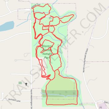
Current Track: 29 SEP 2025 08:19
- Distance: 6.4 Km
- Elevation gain: 62 m
- Maximum elevation: 277 m
- Elevation loss: 62 m
- Minimum elevation: 259 m
- Moving time: 1 h 35 m
- Moving speed: 4.0 Km/h
- Maximum speed: 7.4 Km/h
- Total time: 1 h 38 m
- Global speed: 3.9 Km/h
Interactive trail map
Thank you for supporting this site ❤️
Make a donation
Make a donation
Gear up for your next adventure:
As an Amazon Associate, this site earns from qualifying purchases at no extra cost to you.
Trail profile
- Distance: 6.4 Km
- Elevation gain: 62 m
- Maximum elevation: 277 m
- Elevation loss: 62 m
- Minimum elevation: 259 m
- Moving time: 1 h 35 m
- Moving speed: 4.0 Km/h
- Maximum speed: 7.4 Km/h
- Total time: 1 h 38 m
- Global speed: 3.9 Km/h
Thank you for supporting this site ❤️
Make a donation
Make a donation
Gear up for your next adventure:
As an Amazon Associate, this site earns from qualifying purchases at no extra cost to you.
About this trail
Name: Current Track: 29 SEP 2025 08:19 trail, distance, elevation, map, profile, GPS track
Coordinates: 39.76780 -86.52391 39.77557 -86.51926
Thank you for supporting this site ❤️
Make a donation
Make a donation
Gear up for your next adventure:
As an Amazon Associate, this site earns from qualifying purchases at no extra cost to you.