Thank you for supporting this site ❤️
Make a donation
Make a donation
Gear up for your next adventure:
As an Amazon Associate, this site earns from qualifying purchases at no extra cost to you.
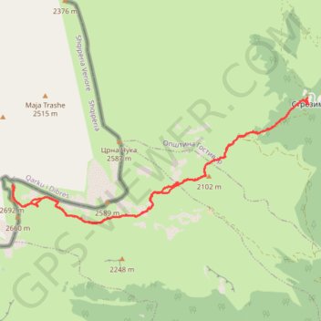
Golem Korab
- Distance: 17.8 Km
- Elevation gain: 1,382 m
- Maximum elevation: 2,728 m
- Elevation loss: 1,383 m
- Minimum elevation: 1,456 m
- Moving time: 6 h 11 m
- Moving speed: 2.9 Km/h
- Maximum speed: 15.1 Km/h
- Total time: 9 h 28 m
- Global speed: 1.9 Km/h
Interactive trail map
Thank you for supporting this site ❤️
Make a donation
Make a donation
Gear up for your next adventure:
As an Amazon Associate, this site earns from qualifying purchases at no extra cost to you.
Trail profile
- Distance: 17.8 Km
- Elevation gain: 1,382 m
- Maximum elevation: 2,728 m
- Elevation loss: 1,383 m
- Minimum elevation: 1,456 m
- Moving time: 6 h 11 m
- Moving speed: 2.9 Km/h
- Maximum speed: 15.1 Km/h
- Total time: 9 h 28 m
- Global speed: 1.9 Km/h
Thank you for supporting this site ❤️
Make a donation
Make a donation
Gear up for your next adventure:
As an Amazon Associate, this site earns from qualifying purchases at no extra cost to you.
About this trail
Name: Golem Korab trail, distance, elevation, map, profile, GPS track
Start: Strezimir, Brodec, Municipality of Gostivar, North Macedonia (41.80612 20.61848)
End: Strezimir, Brodec, Municipality of Gostivar, North Macedonia (41.80618 20.61858)
Coordinates: 41.78345 20.54657 41.80618 20.61889
Thank you for supporting this site ❤️
Make a donation
Make a donation
Gear up for your next adventure:
As an Amazon Associate, this site earns from qualifying purchases at no extra cost to you.