Cane Bayou Trail in Fontainebleau State Park
Cane Bayou Trail offers a serene hiking experience through Louisiana's rich ecosystems, showcasing beautiful bayou views and a diverse range of wildlife. Along the trail, visitors can expect to see lush cypress trees, marsh areas, and various bird species, creating an ideal setting for nature enthusiasts and casual hikers alike. #Hiking #Forest #Nature
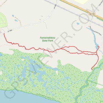
- Distance: 7.4 Km
- Elevation gain: 10 m
- Maximum elevation: 5 m
- Elevation loss: 10 m
- Minimum elevation: 1 m
- Moving time: 1 h 44 m
- Moving speed: 4.2 Km/h
- Maximum speed: 6.0 Km/h
- Total time: 1 h 50 m
- Global speed: 4.0 Km/h
Interactive trail map
Trail profile
- Distance: 7.4 Km
- Elevation gain: 10 m
- Maximum elevation: 5 m
- Elevation loss: 10 m
- Minimum elevation: 1 m
- Moving time: 1 h 44 m
- Moving speed: 4.2 Km/h
- Maximum speed: 6.0 Km/h
- Total time: 1 h 50 m
- Global speed: 4.0 Km/h
About this trail
Name: Cane Bayou Trail in Fontainebleau State Park trail, distance, elevation, map, profile, GPS track
Start: LA 1089, St. Tammany Parish, Louisiana, 70448, United States (30.33733 -90.03723)
End: LA 1089, St. Tammany Parish, Louisiana, 70448, United States (30.33742 -90.03710)
Coordinates: 30.32894 -90.03724 30.33742 -90.01167