Cedar Falls Trail in Petit Jean State Park
The Cedar Falls Trail offers a captivating hiking experience characterized by its moderate difficulty and stunning natural scenery. The trail meanders through lush woodlands and follows the serene Cedar Creek, leading to the picturesque Cedar Falls, a dramatic 95-foot waterfall that creates a striking visual spectacle, especially during wetter seasons. Along the route, hikers will encounter unique rock formations and a footbridge that enhances the overall charm of the journey, making it a worthwhile adventure for nature enthusiasts. #Hiking #Waterfall #Forest #Nature
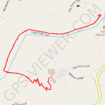
- Distance: 3.1 Km
- Elevation gain: 118 m
- Maximum elevation: 257 m
- Elevation loss: 122 m
- Minimum elevation: 187 m
- Moving time: 1 h 2 m
- Moving speed: 2.9 Km/h
- Maximum speed: 6.5 Km/h
- Total time: 1 h 9 m
- Global speed: 2.6 Km/h
Interactive trail map
Trail profile
- Distance: 3.1 Km
- Elevation gain: 118 m
- Maximum elevation: 257 m
- Elevation loss: 122 m
- Minimum elevation: 187 m
- Moving time: 1 h 2 m
- Moving speed: 2.9 Km/h
- Maximum speed: 6.5 Km/h
- Total time: 1 h 9 m
- Global speed: 2.6 Km/h
About this trail
Name: Cedar Falls Trail in Petit Jean State Park trail, distance, elevation, map, profile, GPS track
Start: Cedar Falls Trail, Conway County, Arkansas, United States (35.11730 -92.93864)
End: Cedar Falls Trail, Conway County, Arkansas, United States (35.11708 -92.93882)
Coordinates: 35.11646 -92.94222 35.12132 -92.93471