Thank you for supporting this site ❤️
Make a donation
Make a donation
Gear up for your next adventure:
As an Amazon Associate, this site earns from qualifying purchases at no extra cost to you.
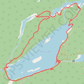
Walking around Parks Lake at Josephine Mine
- Distance: 5.6 Km
- Elevation gain: 111 m
- Maximum elevation: 399 m
- Elevation loss: 111 m
- Minimum elevation: 353 m
- Moving time: 1 h 58 m
- Moving speed: 2.8 Km/h
- Maximum speed: 13.4 Km/h
- Total time: 3 h 55 m
- Global speed: 1.4 Km/h
Interactive trail map
Thank you for supporting this site ❤️
Make a donation
Make a donation
Gear up for your next adventure:
As an Amazon Associate, this site earns from qualifying purchases at no extra cost to you.
Trail profile
- Distance: 5.6 Km
- Elevation gain: 111 m
- Maximum elevation: 399 m
- Elevation loss: 111 m
- Minimum elevation: 353 m
- Moving time: 1 h 58 m
- Moving speed: 2.8 Km/h
- Maximum speed: 13.4 Km/h
- Total time: 3 h 55 m
- Global speed: 1.4 Km/h
Thank you for supporting this site ❤️
Make a donation
Make a donation
Gear up for your next adventure:
As an Amazon Associate, this site earns from qualifying purchases at no extra cost to you.
About this trail
Name: Walking around Parks Lake at Josephine Mine trail, distance, elevation, map, profile, GPS track
Coordinates: 48.11207 -84.63641 48.12305 -84.62017
Topography: Unorganized North Algoma topographic map, elevation, terrain
Thank you for supporting this site ❤️
Make a donation
Make a donation
Gear up for your next adventure:
As an Amazon Associate, this site earns from qualifying purchases at no extra cost to you.