Thank you for supporting this site ❤️
Make a donation
Make a donation
Gear up for your next adventure:
As an Amazon Associate, this site earns from qualifying purchases at no extra cost to you.
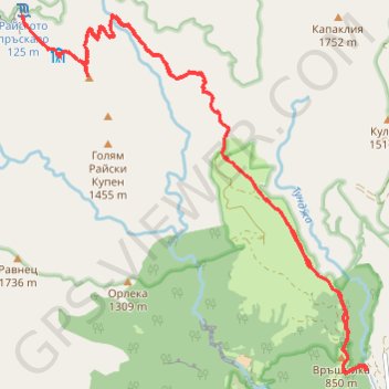
Kalofer - Rayskoto Praskalo
- Distance: 22.6 Km
- Elevation gain: 1,455 m
- Maximum elevation: 1,623 m
- Elevation loss: 1,455 m
- Minimum elevation: 751 m
- Moving time: 5 h 45 m
- Moving speed: 3.9 Km/h
- Maximum speed: 50.7 Km/h
- Total time: 1 d 1 h
- Global speed: 0.9 Km/h
Interactive trail map
Thank you for supporting this site ❤️
Make a donation
Make a donation
Gear up for your next adventure:
As an Amazon Associate, this site earns from qualifying purchases at no extra cost to you.
Trail profile
- Distance: 22.6 Km
- Elevation gain: 1,455 m
- Maximum elevation: 1,623 m
- Elevation loss: 1,455 m
- Minimum elevation: 751 m
- Moving time: 5 h 45 m
- Moving speed: 3.9 Km/h
- Maximum speed: 50.7 Km/h
- Total time: 1 d 1 h
- Global speed: 0.9 Km/h
Thank you for supporting this site ❤️
Make a donation
Make a donation
Gear up for your next adventure:
As an Amazon Associate, this site earns from qualifying purchases at no extra cost to you.
About this trail
Name: Kalofer - Rayskoto Praskalo trail, distance, elevation, map, profile, GPS track
Start: Паниците - х. Рай, Karlovo, Plovdiv, Bulgaria (42.66027 24.97897)
End: Паниците - х. Рай, Karlovo, Plovdiv, Bulgaria (42.66026 24.97893)
Coordinates: 42.65984 24.92536 42.70102 24.97907
Thank you for supporting this site ❤️
Make a donation
Make a donation
Gear up for your next adventure:
As an Amazon Associate, this site earns from qualifying purchases at no extra cost to you.