Thank you for supporting this site ❤️
Make a donation
Make a donation
Gear up for your next adventure:
As an Amazon Associate, this site earns from qualifying purchases at no extra cost to you.
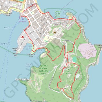
North Head via Blue Fish Track
Interactive trail map
Thank you for supporting this site ❤️
Make a donation
Make a donation
Gear up for your next adventure:
As an Amazon Associate, this site earns from qualifying purchases at no extra cost to you.
Trail profile
- Distance: 9.4 Km
- Elevation gain: 178 m
- Maximum elevation: 101 m
- Elevation loss: 182 m
- Minimum elevation: 1 m
- Moving time: 2 h 2 m
- Moving speed: 4.6 Km/h
- Maximum speed: 7.9 Km/h
- Total time: 2 h 7 m
- Global speed: 4.4 Km/h
Thank you for supporting this site ❤️
Make a donation
Make a donation
Gear up for your next adventure:
As an Amazon Associate, this site earns from qualifying purchases at no extra cost to you.
About this trail
Name: North Head via Blue Fish Track trail, distance, elevation, map, profile, GPS track
Coordinates: -33.81978 151.28417 -33.79720 151.30130
Thank you for supporting this site ❤️
Make a donation
Make a donation
Gear up for your next adventure:
As an Amazon Associate, this site earns from qualifying purchases at no extra cost to you.
Other hiking, mountain biking, running and outdoor activity trails
Click on a trail to view its statistics, map and profile.