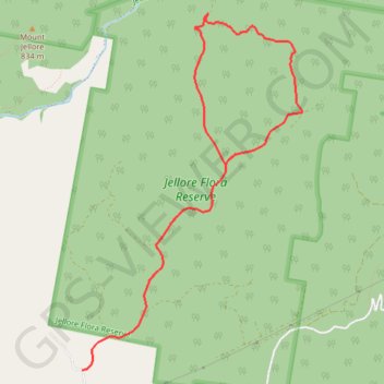
Jellore State Forest Loop
Interactive trail map
Trail profile
- Distance: 10.3 Km
- Elevation gain: 338 m
- Maximum elevation: 763 m
- Elevation loss: 338 m
- Minimum elevation: 522 m
About this trail
Name: Jellore State Forest Loop trail, distance, elevation, map, profile, GPS track
Start: Mount Jellore Lane, Wingecarribee Shire Council, New South Wales, Australia (-34.39971 150.37581)
End: Mount Jellore Lane, Wingecarribee Shire Council, New South Wales, Australia (-34.39971 150.37581)
Coordinates: -34.39971 150.37581 -34.36830 150.39935
Other hiking, mountain biking, running and outdoor activity trails
Click on a trail to view its statistics, map and profile.