Thank you for supporting this site ❤️
Make a donation
Make a donation
Gear up for your next adventure:
As an Amazon Associate, this site earns from qualifying purchases at no extra cost to you.
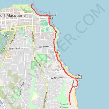
Port Macquarie Coastal Walk
Interactive trail map
Thank you for supporting this site ❤️
Make a donation
Make a donation
Gear up for your next adventure:
As an Amazon Associate, this site earns from qualifying purchases at no extra cost to you.
Trail profile
- Distance: 8.4 Km
- Elevation gain: 182 m
- Maximum elevation: 36 m
- Elevation loss: 171 m
- Minimum elevation: 0 m
- Moving time: 1 h 20 m
- Moving speed: 6.3 Km/h
- Maximum speed: 54.8 Km/h
- Total time: 1 h 22 m
- Global speed: 6.1 Km/h
Thank you for supporting this site ❤️
Make a donation
Make a donation
Gear up for your next adventure:
As an Amazon Associate, this site earns from qualifying purchases at no extra cost to you.
About this trail
Name: Port Macquarie Coastal Walk trail, distance, elevation, map, profile, GPS track
Coordinates: -31.45558 152.91691 -31.42681 152.93238
Thank you for supporting this site ❤️
Make a donation
Make a donation
Gear up for your next adventure:
As an Amazon Associate, this site earns from qualifying purchases at no extra cost to you.