ALTRA100
From Banaue.
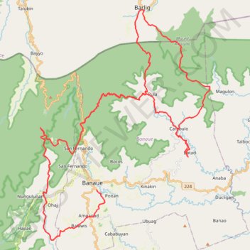
- Distance: 97.5 Km
- Elevation gain: 8,088 m
- Maximum elevation: 2,663 m
- Elevation loss: 8,623 m
- Minimum elevation: 705 m
Interactive trail map
Trail profile
- Distance: 97.5 Km
- Elevation gain: 8,088 m
- Maximum elevation: 2,663 m
- Elevation loss: 8,623 m
- Minimum elevation: 705 m
About this trail
Name: ALTRA100 trail, distance, elevation, map, profile, GPS track
Coordinates: 16.86929 121.02106 17.03932 121.15192
Other hiking, mountain biking, running and outdoor activity trails
Click on a trail to view its statistics, map and profile.
Pula - Cambulo - Batad
Philippines > Ifugao > Banaue > Pula
Distance: 22.1 Km • Elevation gain: 1,717 m • Maximum elevation: 1,816 m