Thank you for supporting this site ❤️
Make a donation
Make a donation
Gear up for your next adventure:
As an Amazon Associate, this site earns from qualifying purchases at no extra cost to you.
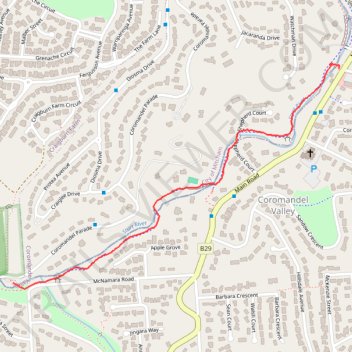
Along the Sturt River
- Distance: 1.6 Km
- Elevation gain: 13 m
- Maximum elevation: 193 m
- Elevation loss: 31 m
- Minimum elevation: 165 m
- Moving time: 18 m 7 s
- Moving speed: 5.3 Km/h
- Maximum speed: 13.4 Km/h
- Total time: 18 m 47 s
- Global speed: 5.1 Km/h
Interactive trail map
Thank you for supporting this site ❤️
Make a donation
Make a donation
Gear up for your next adventure:
As an Amazon Associate, this site earns from qualifying purchases at no extra cost to you.
Trail profile
- Distance: 1.6 Km
- Elevation gain: 13 m
- Maximum elevation: 193 m
- Elevation loss: 31 m
- Minimum elevation: 165 m
- Moving time: 18 m 7 s
- Moving speed: 5.3 Km/h
- Maximum speed: 13.4 Km/h
- Total time: 18 m 47 s
- Global speed: 5.1 Km/h
Thank you for supporting this site ❤️
Make a donation
Make a donation
Gear up for your next adventure:
As an Amazon Associate, this site earns from qualifying purchases at no extra cost to you.
About this trail
Name: Along the Sturt River trail, distance, elevation, map, profile, GPS track
Coordinates: -35.04756 138.61370 -35.04076 138.62572
Thank you for supporting this site ❤️
Make a donation
Make a donation
Gear up for your next adventure:
As an Amazon Associate, this site earns from qualifying purchases at no extra cost to you.